World Wind Software on Linux
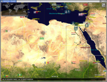
WW2D now runs on Linux using Mono:

World Wind on Linux.
[WW2D] [..] is cross-platform, free and open-source version of NASA World Wind software, see http://worldwind.arc.nasa.gov for details. WW2D allows you to explore Earth using satellite imagery, topographic maps and image from other data sources also providing large placenames and boundaries database and allowing you to install community-made add-ons for even more information about our planet.In basic configuration WW2D uses images from Blue Marble (1 km/pixel), LandSat7 (15 m/pixel), USGS Topo Maps, USGS Digital Ortho imagery, USGS Urban Area imagery.
WW2D is designed to dynamically download needed data from internet, however you can download data you want for faster access and offline usage.
This is not the original NASA software, but a new implementation sharing some of the data. To render they use Tao.OpenGL and a little bit of native code.
The new version is available here to run make sure you have libgdiplus+ installed and then do this:
	$ cd demo-linux
	$ mono WW2D.Frontend.exe
Posted on 30 Sep 2005
Blog Search
Archive
- 2024
Apr Jun - 2020
Mar Aug Sep - 2018
Jan Feb Apr May Dec - 2016
Jan Feb Jul Sep - 2014
Jan Apr May Jul Aug Sep Oct Nov Dec - 2012
Feb Mar Apr Aug Sep Oct Nov - 2010
Jan Feb Mar Apr May Jun Jul Aug Sep Oct Nov Dec - 2008
Jan Feb Mar Apr May Jun Jul Aug Sep Oct Nov Dec - 2006
Jan Feb Mar Apr May Jun Jul Aug Sep Oct Nov Dec - 2004
Jan Feb Mar Apr May Jun Jul Aug Sep Oct Nov Dec - 2002
Jan Feb Mar Apr May Jun Jul Aug Sep Oct Dec
- 2022
Apr - 2019
Mar Apr - 2017
Jan Nov Dec - 2015
Jan Jul Aug Sep Oct Dec - 2013
Feb Mar Apr Jun Aug Oct - 2011
Jan Feb Mar Apr May Jun Jul Aug Sep Oct Nov Dec - 2009
Jan Feb Mar Apr May Jun Jul Aug Sep Oct Nov Dec - 2007
Jan Feb Mar Apr May Jun Jul Aug Sep Oct Nov Dec - 2005
Jan Feb Mar Apr May Jun Jul Aug Sep Oct Nov Dec - 2003
Jan Feb Mar Apr Jun Jul Aug Sep Oct Nov Dec - 2001
Apr May Jun Jul Aug Sep Oct Nov Dec